Canning Stock Route Expedition - Tagalong
- Dauer: 19 Tage
- Produkt-Code: csrtag
Please note that from 2019 we will require a minimum of two people in each tagalong booking. The reason for this is when a single driver becomes incapacitated through illness etc we do not have any drivers to take over. We also allow a maximum of two tagalong passengers per booking only.
Itinerary
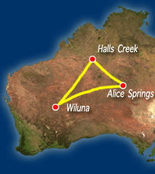
Day One
We meet in Alice Springs, and head north up the Tanami Road. Above the Tropic of Capricorn we stop at Tilmouth Well for morning tea. After lunch just north of Yuendumu we enter the realm of the termite. The vast Tanami Desert stretches before us, the anthills are in places so dense they resemble a city of skyscrapers. We travel through Rabbit Flat and camp just short of the Western Australian border.
Day Two
We visit the Aboriginal community of Balgo and visit the world renowned Warlayirti Art Centre. We will enjoy breathtaking views from the Balgo Pound. On up the track we lunch at Sturt Creek and visit the remarkable Wolfe Creek meteorite crater. We camp on Ruby Plains Station, the only Kidman property in the Kimberley.
Day Three
Halls Creek is on the Great Northern Highway, and will be our last opportunity to take on provisions for the Canning. We return to Billiluna, on Sturt Creek and leave the maintained dirt road. Following the western edge of the Sturt Creek overflow, we arrive at the first Canning Stock Route Well 51, known as Weriaddo. This is the real start of the Canning; it was the delivery camp for the drovers, and the last well constructed by Canning. We camp on a large clapyan near Well 50.
Day Four
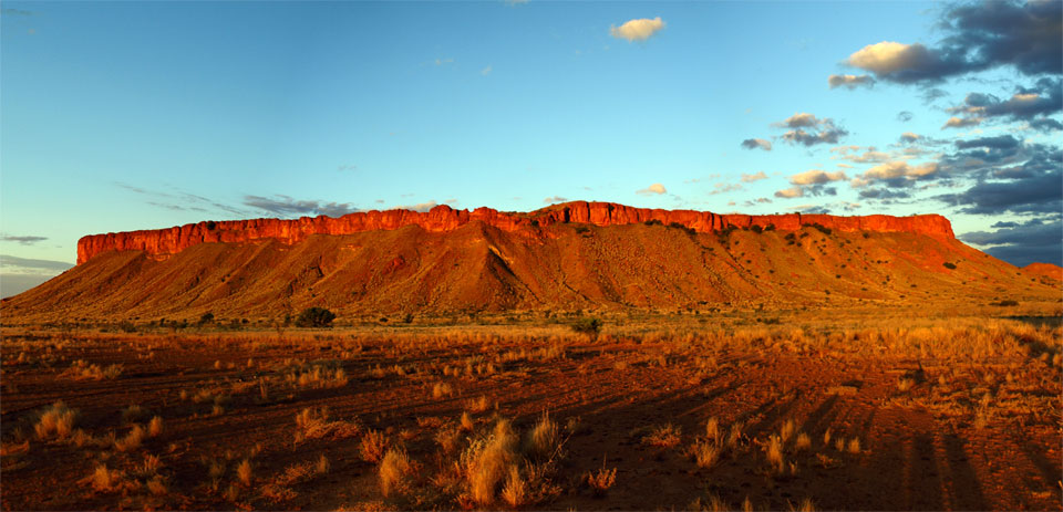
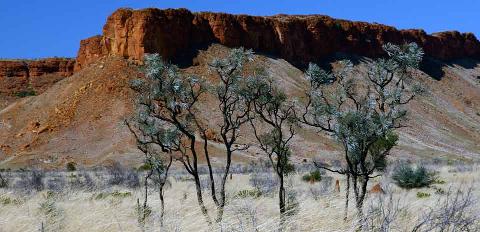
At Well 49 we visit the lonely grave of Jack Smith who died in 1939 after a horse fell on him. Soon we enter the Southesk Tablelands. The spectacular buttresses of the Breaden Hills rise above us. We will explore Breaden Tank, a rock hole with an Aboriginal hide surrounded by massive fig trees and walk to Godfrey's Tank, where explorer David Carnegie and Canning's second in charge Hubert Trotman carved their names into the sandstone. We will continue south to camp on a flat surrounded by Snappy Gums at Well 46.
Day Five
Beyond Well 46 we enter the Great Sandy Desert. Over every sandhill an entirely new landscape presents itself. Sometimes we are in a sea of spinifex with its blonde heads waving in the breeze like a vast wheat field, other times we are in a forest of holly grevillea with it's red inflorescence hanging like Chinese lanterns. We camp at Billowaggie, Well 43.
Day Six
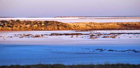
We are in the heart of the big dune country. The track winds its way down to Well 42 at the southern end of Lake Guli, a shallow playa or salt lake mostly covered in brightly coloured samphire. We travel on down to Well 41, which is surrounded by dead melaleucas, victims of the 2001 flooding. It is then on down to Well 40. A kilometre or so behind the well is the grave of Michael Tobin, a member of Canning 1907 Survey Party who was speared by natives.
Day Seven
We cross Lake Tobin, a dry playa, and travel through a fine stand of desert oaks, gradually making our way down to lunch at Water 38, beside a rocky creek. Explorers and drovers have carved their names in the rock here, and there are also some ancient Aboriginal scrapings. After lunch we travel to Well 37 the so-called 'Haunted Well'‚ due to several graves of drovers and prospectors speared or bludgeoned by Aboriginals. We will hear the stories of first contact, and the horrors of the subsequent Police Punitive Expeditions led by Sgt. Pilmer. Beyond the haunted well we enter the area Canning called the Great Oak Forest and here, beneath whispering casuarinas we make our camp.
Day Eight
The day starts with some very rough travel along a track that makes constant detours round areas that were flooded in 2001. Many of the desert oaks have died here. We travel over high lateritic ground and ironstone plains to Kidson Bluff. Here we run down heavily corrugated sections of track to Well 35. We will visit the remote Kunawarritji Aboriginal community store and refuel. There is a chance to shop in their small store and have a shower. We will drive on down to Well 30 and camp beneath impressive stands of Bloodwood trees.
Day Nine
Not too far south we will come to Thring Rock, an impressive sandstone outcrop rising from the sandhills. A short climb to the summit is rewarded with excellent views of the surrounding country- right out to the west you can see Lake Auld, another vast salt lake. Larry Wells named all the features in the area during the Calvert Expedition after members of John McDouall Stuarts party that first crossed the continent. Well 29 is burnt out; nothing remains of well 28, and there is little left of 27 except some old rusted troughing and a couple of timbers. We camp in a magnificent natural amphitheatre in the Slate Range. If you are very quiet and wander about the hills, you might spot some rock wallabies here.
Day Ten
We continue on to Teiwa Well (26), which in 1983 was the first well to be reconstructed. The complete reconstruction of this well gives you a very good idea of what the wells would have been like in their original condition. Shortly the Canning joins the Talawana Track, which if followed 450 km. to the west, one would arrive at Newman. The Talawana Track was surveyed by Len Beadell and built by his Gunbarrel Road Construction Party as part of the network of roads that serviced the Woomera Range. Using a hand pump we will refill our tanks with pure water from Georgia Bore and head to our camp on a sand hill beneath desert oaks with a spectacular view over Lake Disappointment.
Day Eleven
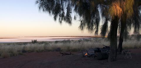
Past impressive stands of Desert Oak and giant termite mounds, we come to Savory Creek, which can be quite boggy and often presents a challenge to get the vehicles across. We continue down to lunch in the dunes near the Tropic of Capricorn. In the afternoon we continue south to the Durba Hills. We track eastwards along the northern flanks of the range, past giant boulders that have fallen from the scarp. Hidden along the range is Durba Springs- described by Dick Smith as one of the most beautiful places in Australia. The Drovers took advantage of its natural pound shape making it an ideal place to make a cattle camp. We camp on soft grass beneath river red gums.
Day Twelve
A day to relax and enjoy Durba and the surrounding countryside.
Day Thirteen
We return to the Stock Route and head south. We now enter the Little Sandy Desert. The dunes are still longitudinal and a deep red colour,. At well 15 we replenish our water supply and travel through the Ward Hills to our camp in the Mulga beyond Lake Aerodrome.
Day Fourteen
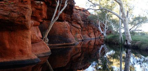
South of Lake Aerodrome the large sand hills recede and we continue on to Weld Springs at Well 9. Here the remains of a stone fort can be seen that was built by John Forrest in 1874 to protect his party against attack by Aboriginals. We continue south around McConkey Hill and travel down to Pierre Springs. The well here has been reconditioned, and is surrounded by majestic river red gums. We encounter a magnificent stand of Grass Trees -Xanthorrhoea preissii -neither grass, nor trees, these magnificent plants are beautiful to look at. We continue on to camp in Mulga near Well 5.
Day Fifteen
At Well 5 we leave the stock route, and travel through station country out to Granite Peak Station, where we pick up the main road in to Wiluna having completed the world's longest and most remote stock route. During the gold rush, Wiluna had twelve taxis, five sporting ovals, three swimming pools, three soft drink factories and four pubs, but in 1947 the mine closed and the population dropped to around 1000. We'll use Wiluna to clean up, both the equipment, and ourselves and re stock for the next leg, the journey back across Australia either on the famous Gunbarrel Highway or the Great Central Road (Please note that we will choose which route we take depending on local conditions at the time). If the weather is dry (which it usually is) we take the Gunbarrel.
Day Sixteen
From camp we travel east to Carnegie Station, the last outpost before the Gibson Desert. At Carnegie we will refuel. There is a store and small museum with information on Len Beadell here. We then travel past Mt. Nossiter to our camp at Mungilli Claypan a RAMSAR listed ephemeral wetland in the Gibson Desert Nature Reserve.
Day Seventeen
From camp we travel to Everard Junction. From here the Gary Highway, another Beadell road heads north. A short walk brings us to the top of Mt. Everard, affording spectacular views of the Gibson Desert. The track is very rocky and rough as it turns southward toward Mt. Beadell. Here you can climb to the top which houses a memorial theodolite to Len Beadell. We continue on past Notabilis Hill to our camp near Mt. Samuel.
Day Eighteen
We travel south along the Heather Highway- named after outback legend David Hewitt's daughter Heather. David is reputed at the time the highway was named to have said, "If its good enough for Len Beadell, its good enough for me". We pick up the Great Central Road at Steptoes Turnoff. From here we travel to Warburton to refuel. We travel north along the Great Central Road and camp on the Rebecca east of Giles Meteorological Station, in view of the Petermann Range.
Day Nineteen
We cross the WA/NT border near Docker River and head due east to Kata Tjuta - The Olgas. It could only be described as culture shock arriving at the tourist circus that is the Uluru National Park. Sleek tour busses, perfumed men and women, shiny street cars, hotels, do this, don't do that signage. Whilst the rock and the Olgas are spectacular, we are not accredited to tour the area and are only permitted to drive through. We refuel at Yulara before stopping for lunch en route to Curtain Springs. You have the option of leaving the tour at Yulara or travelling on to early evening arrival at Alice Springs Hotels.


